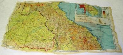
Escape Map [French Indo China]
Object detail
Accession number
2006.267
Description
Ecru-coloured silk escape map - double-sided. Roads in thin red line, thick red line with black running dot for international boundaries, blue line for streams. Front - Map of French Indo China with coastline. Inset map of peninsula including Cambodia, Thailand, French Indonesia, Tenasserim. Between 102 and 110 degrees and 14 - 19 degrees. Back - Central French Indo China and edge of Siam. Inset map of the south portion of the larger map. Between 102 and 110 degrees and 9 - 14 degrees.
Media/Materials
Collection
Credit Line
Escape Map [French Indo China], 2006.267. The Museum of Transport and Technology (MOTAT).


Public comments
Be the first to comment on this object record.