Map [Silk Escape]
Object detail
Accession number
2004.36
Description
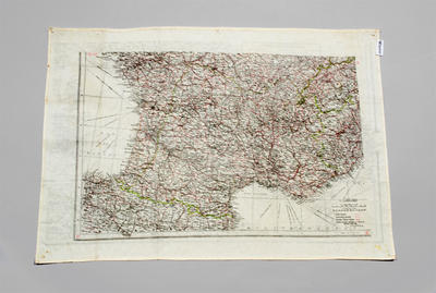
Double-sided, silk, escape map. One side depicts a map of France. Place names and waterways are indicated in black, with roads in red and international boundaries in green. In the corners, the map is marked D or D/H2, in red. The map is marked vertically on a scale of 42-47. There is a horizontal scale on the bottom edge of 2 - 8. The map has a black border. On the reverse is a map of the Western Mediterranean, France, Spain and North Africa. There is a black border around 3 sides of the map. There is a vertical number scale of 36-44 and a horizontal scale of 6-6. H2 is written in red in the corners.
Media/Materials
Collection
Credit Line
Map [Silk Escape], 2004.36. The Museum of Transport and Technology (MOTAT).


Public comments
Be the first to comment on this object record.