Area Map
Object detail
Accession number
F851.2002
Description
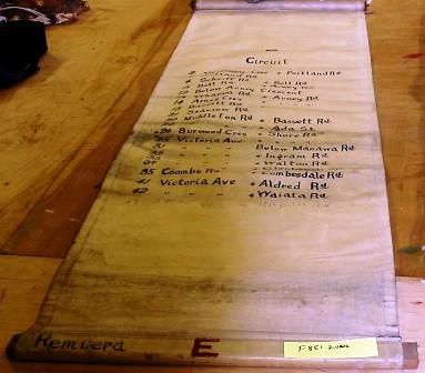
A rolled canvas scroll with a circular wooden pin affixed across the top edge and a rectangular wooden pin along the base. The canvas rolls out and displays a list ranging from 2-43, with various numbers missing in-between, with the street names of circuits printed in black ink. The bottom two street names have been hand written in graphite. The street names are of streets in the Auckland suburb, Remuera.
Marks
E/ Circuit/ 2 Westbury cres. + Portland Rd./ 3 Portland Rd./ 4 Scherff Rd. + Bell Rd./ 5 Bell Rd. + Arney Rd./ 12 Below Arney Crescent/ 13 Wharua Rd. + Arney Rd./ 14 Arney Cres + " " "/ 15 Bassett Rd. + " " "/ 21 Sedview Rd./ 22 Middleton Rd. + Bassett Rd./ 23 " " " + Ada St. / 24 Burwood Cres + Shore Rd./ 25 Victoria Ave + " " "/ 31 " " " Below Manawa Rd/ 32 " " " + Ingram Rd./ 33 " " " + Walton Rd./ 34 " " " + Glenbrook St./ 35 Coombs Rd. + Combesdale Rd./ 41 Victoria Ave + Aldred Rd./ 42 " " " + Waiata Rd./ 43 Shore Rd + Hapua Rd. / Remuera E Hand-written
Media/Materials
Collection
Credit Line
Area Map, F851.2002. The Museum of Transport and Technology (MOTAT).


Public comments
Be the first to comment on this object record.