
Photograph - Airfield
Maker and role
Unknown, Photographer
See full details
Object detail
Accession number
2002.164
Maker
Production period
Description
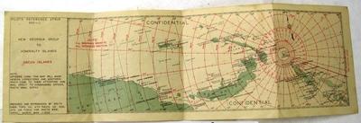
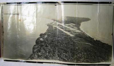
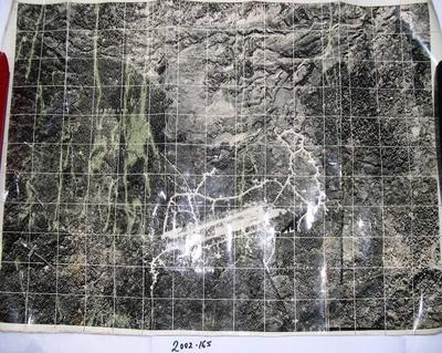
Black and white copy aerial photograph of Nissan Airfield, also known as Green Island Airfield, or Nissan Island Airport. This island is the largest of the Green Island's in Papua New Guinea, and is known as Green Island, Nissan Island or Sir Charles Hardy Island. During World War Two Green Island Lagoon was used by the Japanese Navy as a seaplane operating area. In Feb 1944 Allied troops under Operation Square Peg took control of the island. Post occupation Allied troops constructed Nissan Airfield and two parallel runways, Lagoon Airfield (fighter strip); Ocean Airfield (bomber strip).
This aerial photograph shows Nissan Airfield at coordinates of 349C-OB-VDI 24" x 1800' 4/8/44 (0745) (Zone-11).
This aerial photograph shows Nissan Airfield at coordinates of 349C-OB-VDI 24" x 1800' 4/8/44 (0745) (Zone-11).
Marks
349C-OB-VDI 24" x 1800' 4/8/44 (0745) (Zone-11). Secret Printed
Physical description
1 print : black and white ; 25.5 x 50 cm
Credit Line
Unknown. Photograph - Airfield, 2002.164. Walsh Memorial Library, The Museum of Transport and Technology (MOTAT).
Production place
Papua New Guinea
Melanesia
Melanesia
![AAF cloth map - Southwest Pacific area [No. 16 Owen Stanley -- No. 17 New Britain]; Army Map Service, US Army; 1944](https://collection.motat.nz/records/images/medium/4646/471ded036be82141322a5fc06eadf53e1d365e70.jpg)
![New Britain and New Ireland [map]; United States Hydrographic Office; [1940s]](https://collection.motat.nz/records/images/medium/4658/bc53aef99894204959b584dfb63a6d656e841cb5.jpg)
![[Lakunai Airfield (New Britain) - navigation map]; United States Hydrographic Office; 1940s](https://collection.motat.nz/records/images/medium/4669/c61658116b220859da9d756e99b22575041f9eb5.jpg)
Public comments
Be the first to comment on this object record.